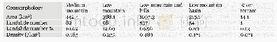
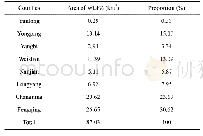
《Table 2 Geomorphology zones of the landslide distribution》
 提示:宽带有限、当前游客访问压缩模式
本系列图表出处文件名:随高清版一同展现
《"Landslide integrated characteristics and susceptibility assessment in Rongxian county of Guangxi,China"》
Based on geological data and field surveyed data,the region with the weathered soil thickness greater than 15 m is largest,followed by the region with the thickness less than 5 m.Therefore thickness is divided into four classes by an equa interval of 5 m as follows:<5 m,5~10 m,10~15 m and>15 m(Figure 3c).43.49%of the slope surface is covered by the residual or fully weathered soil of granite,shale,mud rock and sandstone,which is prone to soil failure in rainy season.513(66.45%)landslides are situated within the region with the thickness greater than 15 m and the growth density of 0.523/km2.The smallest growth density exists within the region where the thickness is less than 5m(Table 3).
| 图表编号 | XD0056568900 严禁用于非法目的 |
|---|---|
| 绘制时间 | 2019.03.01 |
| 作者 | LIAO Li-ping、ZHU Ying-yan、ZHAO Yan-lin、WEN Hai-tao、YANG Yun-chuan、CHEN Li-hua、MA Shao-kun、XU Ying-zi |
| 绘制单位 | College of Civil Engineering and Architecture,Guangxi University、Key Laboratory of Disaster Prevention and Structural Safety of Ministry of Education,Guangxi University、Guangxi Key Laboratory of Disaster Prevention and Engineering Safety,Guangxi Universit |
| 更多格式 | 高清、无水印(增值服务) |

