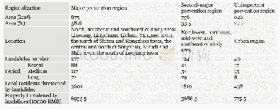
《Table 9 Three prevention regions》
 提示:宽带有限、当前游客访问压缩模式
本系列图表出处文件名:随高清版一同展现
《"Landslide integrated characteristics and susceptibility assessment in Rongxian county of Guangxi,China"》
Based on the section 4.2,firstly,441 landslides are selected in the high and moderate susceptive zone.Secondly,the characteristics of landslide development and the region system planning(2017-2025)are considered to conduct a comprehensive analysis on prevention zones.According to the urgency of the prevention,the planning period is divided into three phases:recent(2017~2019),medium-term(2020~2022)and long-term(2023~2025).The prevention zone is classified into the major,second-major and unimportant region.As shown in Table 9,the major prevention region threatened by 277landslides is located in the north,southeast and southwest.This region is distributed around towns villages,roads and important engineering facilities.It covers an area of 875 km2 accounting for 38.8%of the total area and has 3601 local residents.The second-majorpreventionregionwith124landslides is located in the northwest,northeast,mid-west and southeast.Its area is 756 km2accounting for 33.5%,and the number of residents is 1819.Unimportant prevention region is sparsely populated rural areas with flat terrain and few human activities.It covers an area of 626 km2accounting for 27.7%.
| 图表编号 | XD0056568500 严禁用于非法目的 |
|---|---|
| 绘制时间 | 2019.03.01 |
| 作者 | LIAO Li-ping、ZHU Ying-yan、ZHAO Yan-lin、WEN Hai-tao、YANG Yun-chuan、CHEN Li-hua、MA Shao-kun、XU Ying-zi |
| 绘制单位 | College of Civil Engineering and Architecture,Guangxi University、Key Laboratory of Disaster Prevention and Structural Safety of Ministry of Education,Guangxi University、Guangxi Key Laboratory of Disaster Prevention and Engineering Safety,Guangxi Universit |
| 更多格式 | 高清、无水印(增值服务) |
![表3 培训前后医务人员丙肝诊断和防护知识的知晓情况[N (%) ]Table 3 The awareness of diagnosis and prevention knowledge about hepatitis C among med](http://bookimg.mtoou.info/tubiao/gif/AHYF201801011_06200.gif)
![Table 6:Mn-equivalent for several elements favoring (+) or preventing (-) pearlite[3]](http://bookimg.mtoou.info/tubiao/gif/ZZAF201902001_11900.gif)