《Table 6 Comparison of the locality of the Chinese farming-pastoral ecotone in the northern, central
 提示:宽带有限、当前游客访问压缩模式
本系列图表出处文件名:随高清版一同展现
《Regional difference and dynamic mechanism of locality of the Chinese farming-pastoral ecotone based on geotagged photos from Panoramio》
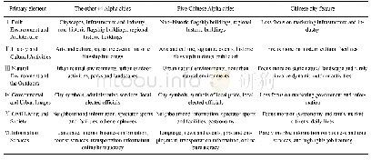
Meanwhile,the locality of the farming-pastoral evolution strongly reflects the different influences of environmental changes and human activities.The existing research made an assessment of the driving factors of North China characteristics from the perspectives of ecology and physical geography.For example,Ma et al.(2017)adopted remote sensing maps to analyze and compare the influences of climate factors and human activities in North China on vegetation change;Sha et al.(2017)adopted geo-mathematical models to evaluate the correlation between climate factors,human activities,and grassland productivity in China's Inner Mongolia region.We identified the locality elements using GIP,conducted associations using their typicality and peculiarity assessments,and concluded with the association of features and spatial and temporal patterns of locality elements,as shown in Table 6,thereby contributing to the profound understanding of the dynamic mechanism of the locality of the Chinese farming-pastoral ecotone in different regions.
| 图表编号 | XD0020360900 严禁用于非法目的 |
|---|---|
| 绘制时间 | 2018.04.01 |
| 作者 | WANG Fang、LI Yixi、DONG Ying、ZHU Xiaohua |
| 绘制单位 | Sino-German Joint Laboratory on Urbanization and Locality Research (UAL), College of Architecture and Landscape Architecture, Peking University、Key Laboratory for Earth Surface Processes, Ministry of Education, Peking University、Sino-German Joint Laborato |
| 更多格式 | 高清、无水印(增值服务) |
