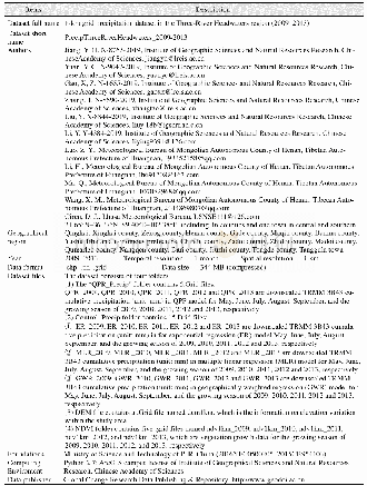
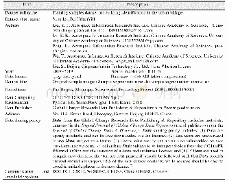
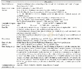
《Table 1 Metadata summary of“Variation dataset of land use and its ecosystem service value in Yarkan
 提示:宽带有限、当前游客访问压缩模式
本系列图表出处文件名:随高清版一同展现
《1978–2018年叶尔羌河流域土地利用及其生态服务价值变化数据研究》
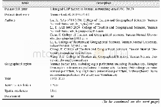
The Yarkant River basin(35°50'N–40°31'N,74°28'E–80°54'E)is located in the southwest of Xinjiang Uygur autonomous region(Figure 1)[11],at the western margin of the Tarim River basin.The Yarkant River basin enjoys rich light and heat resources.Because of the blocking effect of the Pamir Mountains,Karakoram Mountains,and southern Tianshan Mountains,the warm and moist air of the Atlantic and Indian oceans cannot reach the Yarkant River basin,resulting in perennial drought and dry conditions,with an average annual rainfall of only 30–60 mm and a typical continental climate[5].The Yarkant River basin sees only a small annual temperature change but does have abundant solar-thermal resources.The average temperature range is 11.4–12.3°C and the long frost-free period provides climatic conditions that are very helpful for regional agricultural production.The middle area of the Yarkant River basin is highly suited to the cultivation of long-staple cotton and melons as well as other fruits.Thus,this region is famous for cotton,dry fruits,and fruit production(walnuts,almonds,red jujube,and pomegranate)[12].In the Yarkant River basin,the pressures of economic development and ecological protection coexist.In the past few decades,with rapid regional changes in land use,the regional eco-environmental structure has changed dramatically.Therefore,the rational exploitation of natural resources and sustainable development of the eco-environment is essential in achieving societal goals.Understanding the current ecological and environmental changes has great significance in terms of coordinating the economic development,ecological protection,and sustainable development of this arid region.
| 图表编号 | XD00153337800 严禁用于非法目的 |
|---|---|
| 绘制时间 | 2020.03.25 |
| 作者 | 王建平、阿依努尔·买买提、马元旭 |
| 绘制单位 | 中国科学院空天信息创新研究院喀什卫星地面站、中国科学院空天信息创新研究院喀什卫星地面站、中国科学院空天信息创新研究院数字地球重点实验室 |
| 更多格式 | 高清、无水印(增值服务) |