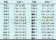
《表1 航迹节点与障碍物分布表Tabel 1 Path node and obstacle distribution》
 提示:宽带有限、当前游客访问压缩模式
本系列图表出处文件名:随高清版一同展现
《一种基于差分进化混合粒子群算法的多无人机航迹规划》
航迹节点以及障碍物分布如表1所示,节点1为起点,节点15为终点,设定了15个航迹节点,7座建筑物以及2个威胁区域,通过算法仿真最终分别得到如图4和图5所示的2架无人机和3架无人机航迹规划。其中,7个圆柱形区域为楼房建筑障碍物,2个半球形区域为威胁区域,航迹节点在图中1~15处。
| 图表编号 | XD0014885300 严禁用于非法目的 |
|---|---|
| 绘制时间 | 2018.05.01 |
| 作者 | 于鸿达、王从庆、贾峰、刘阳 |
| 绘制单位 | 南京航空航天大学、南京航空航天大学、南京航空航天大学、南京航空航天大学 |
| 更多格式 | 高清、无水印(增值服务) |

