《Table 2 Island classification by area and code》
 提示:宽带有限、当前游客访问压缩模式
本系列图表出处文件名:随高清版一同展现
《2015年全球岛(礁)有多少陆地面积及海岸线长几何——基于Google Earth遥感影像的数据结果》
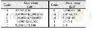
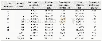
The area of the global islands greatly varies with the largest area of Greenland reaching2,112,450.44 km2[25],and the smallest area of rocks remaining 6 m2.According to the area,this dataset divides the islands into 10types,i.e.,200,000,100,000,10,000,5,000,1,000,100,50,10,and 1 km2,assigningA-J codes to each type,respectively.Their definitions are shown in Table 2.
| 图表编号 | XD00110312100 严禁用于非法目的 |
|---|---|
| 绘制时间 | 2019.06.25 |
| 作者 | 刘闯、石瑞香、张应华、申艳、马军花、吴立宗、陈文波、Tomoko Doko、陈利军、吕婷婷、陶醉、诸云强 |
| 绘制单位 | 中国科学院地理科学与资源研究所、中国科学院地理科学与资源研究所、中国科学院地理科学与资源研究所、中国科学院地理科学与资源研究所、中国科学院地理科学与资源研究所、中国极地研究中心、日本庆应义塾大学SFC研究所、日本自然与科学咨询公司、日本庆应义塾大学SFC研究所、日本自然与科学咨询公司、国家基础地理信息中心、中国科学院空天信息研究院、中国科学院空天信息研究院、中国科学院地理科学与资源研究所 |
| 更多格式 | 高清、无水印(增值服务) |
查看“Table 2 Island classification by area and code”的人还看了

-
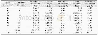
- Table 15 Number,shoreline length,and area of islands in North America by area classification in 2015

